
{{ copy.home.heroTitle }}
{{ copy.home.heroBody }}
{{ copy.home.multiDomainNote }}
{{ grp.title }}
{{ grp.sub }}
{{ copy.home.startHereTitle }}
{{ copy.home.startHereBody }}
{{ copy.home.statewideTitle }}
{{ copy.home.priorityTitle }}
{{ copy.home.priorityBody }}
{{ copy.home.statesTitle }}
{{ copy.home.needTitle }}
{{ copy.home.needBody }}
{{ copy.home.planTitle }}
{{ copy.home.planBody }}
Understanding rural health needs across each parish
Health needs and access to care vary across Louisiana. RHTLA brings together statewide data to help identify where needs are greatest, where barriers to care exist, and how communities compare.
Use the parish picker in the summary sentence, or click a parish on the tile map, to open a specific parish profile.
Is my location rural?
Find out whether a Louisiana location counts as rural for Rural Health Transformation Program (RHTP) funding. Enter a ZIP code, address, or organization name. You'll get an answer, the record we matched it to, and what to do next.
ZIP code gives the most reliable match. Searching by name shows up to six possible matches — check the address before you use one.
Check many locations at once
Upload a spreadsheet and get a result for every row. Useful if you're preparing an application covering several sites.
Your file needs one column named name, address, or zip. Up to 100 rows. Results appear below.
{{ ruralityOutcomeTitle }}
{{ ruralityOutcomeBody }}
What to do next: {{ ruralityOutcomeNext }}
{{ ruralityOutcomeNote }}
{{ ruralityResultsHeading }}
Meets the geographic rural definition
This location meets the geographic rural criteria used for Pathway 1 of RHTP rural eligibility. Final eligibility remains subject to the requirements and review process of the applicable funding opportunity.
Does not meet the geographic rural definition
This location does not currently meet the geographic criteria for Pathway 1. That does not necessarily mean the organization is ineligible. Other pathways may apply based on facility designation or the rural communities served by the organization.
See how Pathway 2 and Pathway 3 work →Not enough information available
The available data are not sufficient to determine the geographic rural status of this location. This does not mean the location is not rural and does not prevent an organization from applying for eligible funding opportunities.
Try searching by ZIP code instead.
Three ways to qualify — you only need one
RHTP uses three separate tests. Passing any one of them meets the rural requirement.
A location qualifies if it sits in an area the federal government designates rural — RUCA codes 4 through 10, or a ZIP classified Rural or Partially Rural. This page checks Pathway 1 automatically.
Pathway 2 guidance is being confirmed with ORHTS and is not published here yet. This page does not check Pathway 2. Check the funding notice you're applying under for current requirements.
If more than half of your active patients live in rural ZIP codes (RUCA 4–10), you qualify even if Pathways 1 and 2 don't. You'll need your patient ZIP code counts to show this. Provide your patient data in the application. This page does not check Pathway 3.
Current rurality methods don't reach every patient
Census-tract codes like RUCA classify geography, not people. A clinic on the "wrong" side of a tract line, a new road that changed drive times, or a practice type no registry enumerates can all leave a genuinely rural patient outside the definition.
RHTLA's work is to expand the reach of these methods — layering drive time, service availability, and enumeration coverage on top of the federal codes — with the patient at the center of the determination, not the tract.
Terms used on this page
- RUCA
- Rural-Urban Commuting Area. A federal code from 1 to 10, based on where people in an area commute for work. Codes 4 through 10 count as rural.
- FORHP
- The Federal Office of Rural Health Policy, which maintains the federal list of rural areas.
- Partially Rural
- A ZIP code containing both rural and non-rural areas. It passes Pathway 1.
- Transitional At-Risk
- A flag on locations close to the rural cut-off. It warns that the classification could change as population or commuting patterns shift. It doesn't change your result today.
- Source date
- When the record you matched was last updated.
{{ parishName }} Parish
Need indicators
Indicators were selected when they were statewide, reproducible, relevant to rural health decisions, and maintained by a named public steward. They are grouped into vetted domains below. Bars show this parish (navy) vs. state (hairline).
Services on file
One record per location, counted from the same facility registry the Atlas map uses. This is a count of what's on file, not a measure of how complete that registry is against the real number of facilities — a zero means "none on file," not "none exists."
RHTP in this parish
Ask Atlas AI about this parish
Plain-language questions, answered from the Atlas data with sources shown. Any answer can be exported to PDF for planning notes or an application.
Next steps
Understanding rural patient needs, by domain
Statewide views · source dates shown{{ areaName }}
{{ areaSummary }}
{{ areaChallenge }}
{{ areaResponse }}
Follow Louisiana's rural health transformation
Louisiana's Rural Health Transformation Program (RHTP) is working to strengthen rural healthcare and improve health outcomes over the next five years. Our priorities include making rural healthcare sustainable, high quality, data-driven, and patient-centered.
RHTLA provides a public view of program activities, goals, and progress, so communities can see what is being addressed, where activity is occurring, and how progress is being measured. Figures are sourced and dated throughout this page.
What is Louisiana working to achieve?
Explore key goals included in Louisiana's Rural Health Transformation Program, and follow progress from baseline measures toward five-year targets.
Committed outcomes: establishing baseline
As of: {{ asOf }}The four headline targets from the state's application to CMS. Progress bars run baseline → Year-5 target.
(All committed outcomes are reported to CMS)
Projects identified for funding
Identified projects are grouped by organization type and priority region.
Funding status matters: a project identified for potential funding is not a final award. Project status will be updated as funding decisions and implementation progress are confirmed.
Explore projects identified through the Rural Health Transformation Program, including the communities and health priorities they are designed to address.
{{ funding.title }}
{{ funding.body }}
{{ fr.name }}
{{ fr.desc }}
{{ funding.beforeTitle }}
- {{ fb.text }}{{ fb.action }} →
{{ funding.noticesTitle }}
{{ funding.noticesBody }}
Every figure has a source, a source date, and a method
RHTLA is built to be checked. This page lists what the platform holds, how complete it is, and how the rural accessibility index is computed — so a determination can be reproduced by anyone.
Selected source inventory
Highlights primary sources used across the public Atlas. Not the complete field-level data dictionary; expanded documentation planned with the full methodology package.
Facilities on file by type
Counts show records currently carried in the Atlas — they describe the registry, not a verified census of every operating facility.
Rural accessibility index
A 0–100 composite of need and access, computed per ZIP and rolled up to parish:
The three-state model
No silent blanks. Every lookup returns verified rural, verified not rural, or not enumerated — and a "not enumerated" result is a statement about the registry, never about the place.
Reporting a problem with a figure
If a count, indicator, facility record, or rurality result looks wrong, report it from the page where you saw it. The form captures the parish, ZIP, facility, or indicator in question so the RHTLA team can trace the record to its source. Each report receives a reference number.
If a count, indicator, facility record, or rurality result looks wrong, tell us through the LDH contact form. Please include the parish, ZIP, facility, or indicator in question and the page where you saw it so the RHTLA team can trace the record to its source.
For researchers
Full methodology documentation, a REST API specification, and bulk extracts are planned but are not yet published. The rural eligibility methodology below is available now.
Read the methodology (PDF) →Closing the gap between data and decisions for Rural Health
RHTLA brings a clear, shared, sourced, transparent picture of the facts to every decision about rural health in Louisiana: where to expand a clinic, where broadband is missing, where a program is falling short. When residents, providers, and policymakers see the same evidence, resources reach the communities that need them most.
RHTLA brings together information otherwise scattered across agencies, datasets, and systems: community health needs, healthcare services and facilities, rural eligibility, and Rural Health Transformation Program (RHTP) activities into a single public, transparent platform.
Who this is for
Built with academic rigor
RHTLA is designed and developed by the Center for Applied Artificial Intelligence (CAAI) at the University of Louisiana at Lafayette, in collaboration with the Louisiana Department of Health, the Louisiana Center for Health Innovation (LCHI), and NSF AHeAD. The AI assistant is grounded in named Atlas sources and always shows its evidence, and the tool is tested regularly with rural providers, patients, and researchers to keep it accurate and clear.
Want the details — data sources, index methodology, or how we evaluate the assistant? See Data & methods →
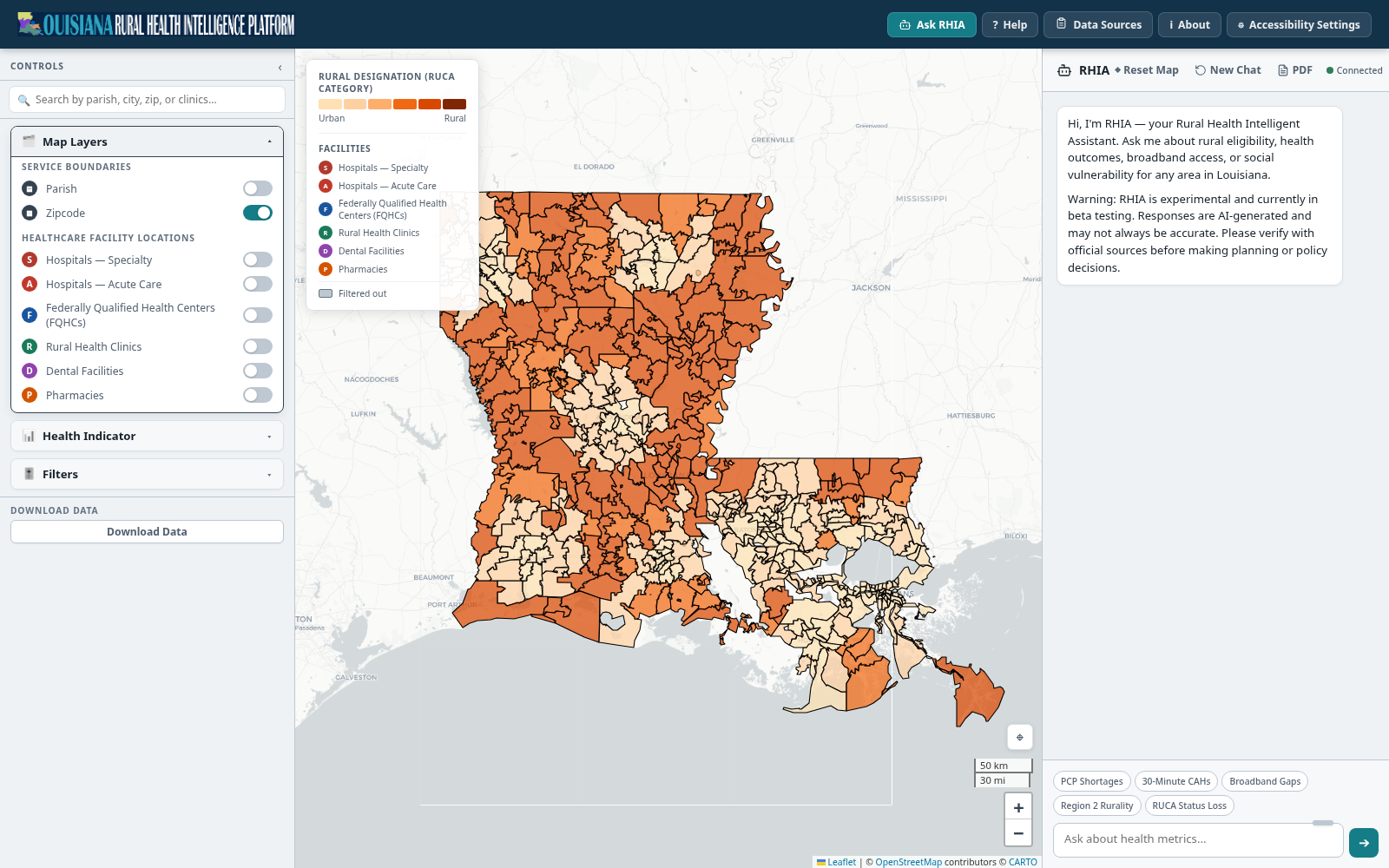
How to use the Atlas
Choose a parish or ZIP, turn facility layers on and off, inspect a source-labeled indicator, or ask the assistant a question.
- Search for your parish or ZIP code to see local facilities, health indicators, and program activity.
- Turn facility layers on and off — hospitals, FQHCs, rural health clinics, dental, and pharmacies — to see what's nearby.
- Click any indicator to see its source and how current it is.
- Ask RHIA, the AI assistant, a question about broadband, workforce, or access to care in plain language.
If a facility count reads zero, check the source and registry notes next to it — it usually means the record isn't on file yet, not that nothing exists there.
 Open the Atlas →